Showing posts with label Makati City. Show all posts

Wednesday, January 28, 2009

BART GUINGONA CELEBRATES 25 YEARS


Click on image to enlarge.


SUPERPASYAL is a supporter of the Ayala Musem.

Friday, August 08, 2008

ARAW NG MAYNILA FEATURE: THE PASIG FERRY ADVENTURE - FROM PLAZA MEXICO TO GUADALUPE (PART UN)

This is a nice view from the side of the terminal; there's the Manila Central Post Office, FEATI and SM Carriedo with its characteristic disk roof (not rotatory, I'm afraid). There's a man paddling his small boat behind one of the catamarans. On this day, several milkfishes have been released by the recent typhoon from their pens at the Laguna de Bai hence the riverbanks are full of people hoping to get the chance to catch something for lunch.

A ferry, bathed in light, sits beside the terminal awaiting its passengers. The river is very calm today.

Another one is slowly perking beside the first ferry.

Now there's two of them side by side. There's only one gangplank. You get to the other ferry through the first one which is right beside the terminal. Amusing, isn't it?

Leaving the terminal now, yipeee! An adventure trip come true! The Plaza Mexico terminal retains the flavor of Spanish-period Filipino architecture. This is in compliance with the rules that govern the Walled City and its environs as enforced by the Intramuros Administration.

The first (or last) station is Plaza Mexico named after the commemorative plaza nearby. The Plaza celebrates 100 years of Philippine-Mexican Friendship.

This hollow shell of a building is the Pacific Commercial. It used to house Citibank. Despite having fallen into disuse, however, it still retains most of its beauty and still exudes strength and power.

Jones Bridge. This end lies on the side of Binondo, Manila's Chinese old business district. From here you can see the famous fried chicken house, SAVORY.

I am reminded of the brass sculpture of little boys jumping into the river in Singapore which you can also see when you take the river tour from Boat Quay.


Our first stop was Escolta Station. The station is a delight to watch from the Jones Bridge. It is very clean and compact, standing as it is on the renovated portion of the Muelle del Banco in Escolta, Manila's first financial and business district.


The majestic, neo-classical 82-years old (c. 1926) Manila Central Post Office basking in the sun. It was designed by Juan Marcos de Guzman Arellano. The Jones Bridge above was also designed by Arellano, but do note that the Jones Bridge we know now isn't the original as most of these Arellano structures were destroyed during WWII. Anyway, please find below a photo of how the original structure looked like courtesy of The National Archives.
Moving on...

On your left is the FEATI University, the only university in the country (or probably in the world) with a light rail transit bisecting its campus. For most of us who spent our childhood in Manila (and in these parts of the metro), we remember with fondness the words, LOOK UP, YOUNG MAN, LOOK UP.

QUIAPO STATION. I was very disappointed when we reached the Quiapo Station. I mean, there's no station to speak of as if putting this stop here was just an afterthought. The squalor surrounding this area is just too difficult to comprehend. Here you can also see the Quiapo (Quezon) Bridge with its moderne concrete posts. Beneath is Quinta Market, famous for its numerous shops selling Philippine traditional handicrafts.
No, this isn't the market I was referring to earlier. :-(

AYALA BRIDGE. This bridge, Ayala Bridge, heralds the entrance of the ferry into the territory of the Hospicio de San Jose. Located at the Isla de Convalescencia, Hospicio de San Jose is a Catholic Welfare institution and a home of orphans, abandoned and special children and elderly people. Let me post here its history (courtesy of the Archdiocese of Manila website):

The establishment of Hospicio de San Jose was made possible y the charitable legacy of Don Francisco Gomez Enriquez and his wife Dona Barbara Versoza. In gratitude for having been cured of a fever, Don Francisco donated four thousand pesos (P4,000) in 1778 for the establishment of a Hospicio General for the poor of Manila. It was said that several others followed the first sum during the couple's lifetime.

Unfortunately, they did not live long enough to see the actual foundation of this home they envisioned to take care of the city's poor and unwanted children.The initial purpose of the establishment of the institution was mainly to respond to the urgent need of the indigent clientele and the mentally/physically handicapped people during those times.

Since its foundation in October 1778, Hospicio de San Jose has continued to meet the needs of the indigent people including the physically handicapped and the elderly people.The institution was first known as Hospicio General and was later changed to its present name Hospicio de San Jose. The newly established welfare institution was then named after St. Joseph, its present saint.

Hospicio de San Jose was formerly located at Pandacan, and then transferred to Intramuros, then to Binondo, Nagtahan and Echague. It was only 1810 when Hospicio de San found its permanent home at the Isla de Convalescencia or the Island of Convalescents.On December 27, 1810, a Board of Directors governed Hospicio ded san Jose through a Royal Decree, under the chairmanship of the Archbishop of Manila. The Daughters of Charity of St. Vincent de Paul came to Hospicio de San Jose only on June 1, 1866 as the administrators and were entirely responsible for the whole operation of the institution.

One of Manila's prominent ladies, Dona Margarita Rojas who was also one of its benefactors suggested to the Governor General to invite the good sisters of Charity to come to the Philippines to take care of the island's poor, sick, handicapped and abandoned
.


ARAW NG MAYNILA FEATURE: THE PASIG FERRY ADVENTURE - FROM PLAZA MEXICO TO GUADALUPE (PART DEUX)


Part Two of our Pasig River Ferry coverage begins with the Nagtahan Bridge, still in the city of Manila. Nagtahan Bridge is the largest among all the bridges which crosses the river Pasig. It is also known as Mabini Bridge because it is quite near the Mabini House, which is inside the compound of the Presidential Security Group of the Malacañan Palace complex. This area of Manila is called Pandacan.

TRIVIA: The Pasig River is crossed by a number of bridges in the city of Manila alone. Eastward, they are the Roxas Bridge (commonly referred to as the Del Pan Bridge), Jones Bridge, McArthur Bridge, Quezon Bridge, Ayala Bridge, Nagtahan Bridge (also known as Mabini Bridge), Pandacan Bridge, and the Lambingan Bridge.

Outside the city of Manila, the following bridges cross the Pasig: Makati-Mandaluyong Bridge, Guadalupe Bridge, Carlos P. Garcia-C5 Bridge, Sixto Antonio-Bambang Bridge, Arsenio Jimenez-Kalawaan Bridge, and the C6 Bridge. Have you lost count already? :-)


Established in 1574 by Franciscan missionaries, Pandacan is widely known today as the place where major oil depots of the country are found. The name Pandacan came from the local pandan tree (Scientific name: Pandanus fascicularis Lam) grew abundantly along the banks of the river. It was originally designed to be Manila's industrial center hence the presence of refineries and factories in the area. Among notable national figures who hail from Pandacan is Apoliniario Mabini. It was home to Francisco Baltazar and Lope K. Santos. Imelda Marcos considered it her home in Manila pre-Malacañang days. Incidentally, portions of the Presidential Palace are actually in the Pandacan territory so I guess history has a way of playing with our lives and imagination.

It is also famous for its Cathlic church which honors the Sto. Niño de Pandacan.

A Pasig Ferry being repaired and outfitted along the route.

The Polytechnic University of the Philippines (PUP) Station, the only school stop of the ferry service. Hyacinths hug the station from all sides. PUP is a state university located in Sta. Mesa. It was established in 1904 as the Manila Business School as part of the city school system. It was renamed as the Philippine School of Commerce and was merged with the Philippine Normal School from 1933 to 1946. By virtue of Republic Act 779, the PSC was again changed to Philippine College of Commerce in 1952 which subsequently was converted into a chartered state university now known as the Polytechnic University of the Philippines by virtue of Presidential Decree Number 1341 issued by the President of the Philippines on April 1, 1978. Whew! What a lot of name changes!

An old, rusty railway bridge. Pandacan was a major terminal stop for the 121-years old Philippine National Railways (c. 1887 as Ferrocarril de Manila-Dagupan; cornerstone laying of the Tutuban station). The line begins at Sta. Mesa and ends at Pandacan (not very long, isn't it?). I might have gotten my data wrong. Will update this portion later.


Oil tanks. Name it, they just might have it!


Residencias Manila, begun during the term of former Manila Mayor Lito Atienza. There are housing projects...

... and then there are housing projects.

The past several years has seen the demolishment of houses that have been built over the river.


One of the houses has a streamer that reads, "Bahay mo, Ipaglaban mo!". This pretty much speaks of the continuing fight of the urban poor for a home of their own in this increasingly tight, busy, and dog-eat-dog world of Metro Manila.

The Lambingan Station marks the end of the Manila part of the route. Sta. Ana, where Lambingan is, is the border of the city with Makati.
Lambingan Bridge.

It was nice to see thick foliage in this area. I hope more trees are planted along the route. Some of the spots in Pandacan were really depressing.


Sunday, July 13, 2008

ARAW NG MAYNILA FEATURE: THE PASIG FERRY ADVENTURE - FROM PLAZA MEXICO TO GUADALUPE (PART TROIS)


The sight of the Power Plant Mall signals that we have arrived in the City of Makati (former name: San Pedro de Makati, shortened to Makati on by Act 2390 of the Philippine Legislature in 1914). A coal-powered power plant used to stand on this very spot hence the name of the mall. It was incorporated into the Rizal Province in 1901 and was separated yet again in 1975 and became an independent city in 1995 (RA 7584). In July of 1937, Makati became the home of Manila's first airport, the Nielson Field, using 42 hectares of land leased from the Ayala family. Philippine Airlines' inaugural flight took off from Makati for Baguio in March of 1941. The former runways are now known to us as Paseo de Roxas and Ayala Avenue. The former airport tower, known as the Nielson Tower, is now the permanent home to the Filipinas Heritage Library. :-) More on this in a future post.

Without a doubt the trip can be described as leisurely and one can really sit back, relax, and take in all the view possible from your side of the ferry. To be honest, not all of the scenery is worth taking photos of. Anyway, you can always bring a book with you to read during the unexciting spots.
The ferry seats are wide and comfortable despite being made of tough plastic. The airconditioning doesn't make the interiors very cold, but otherwise the temperature inside is tolerable.

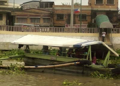
This looks dangerous, but this serves as the fastest way to cross the river for residents along the Pasig. It takes the place of the jeepney which takes the circuitous route. This one goes straight from point A to B with ease. It's the route Superman would have taken, you know.

Some of Makati's high rises loom into view.

The controversial billboards of Guadalupe Viejo. They have been stripped bare because of the recent typhoon which hit the metro. TRIVIA: On Bernardino St. of Guadalupe stands the city's oldest and most historical landmark, the Sanctuario de Guadalupe, which was restored during the leadership of the revered Cardinal Jaime Sin.
A white-and-blue MRT coach crosses the rail bridge atop the Guadalupe bridge. Methinks the MRT system is a gift we all should be thankful for. I can't imagine traveling from North Manila to the South without this train system. Think hours of being stucked in traffic!
The Guadalupe bridge comes into view with the Guadalupe MRT Station above it.
The water may be generally brown but at least it isn't black - which is what it was several years ago before the revive-the-Pasig (Buhayin ang Pasig) movement. Already, signs of life have returned to Manila's most important river.
A play with words, this is what this is. "Pasiglahin" comes from the Tagalog word sigla which means vitality, ergo the tagline Ilog Pasiglahin means to restore the river's vitality. Not bad for a long-term plan (IF it is long term at all, but I'm crossing my fingers).


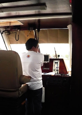
A quick peek into the bridge reveals very simple mechanisms for moving this ferry about. You can trust Filipino sailors in doing a great job in this business.


I'm very excited about this tap card! Finally the technology has reached us in Manila. This is the system widely used in Singapore and Hong Kong.


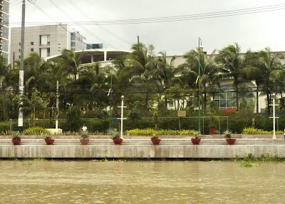
Our ferry leaves Guadalupe to proceed to the few last stations in Pasig City. Note the beautification done by the City of Makati on the waterfront. Soon there's be tap card or mCASH card for those who use the system frequently. It saves the trouble of having to line up and sign your name on the manifest every time you ride the ferry.
This was our last stop - Guadalupe Station in Makati City. From here, people working in these parts can take connecting jeepney rides to their offices. It can be convenient on a clear day, but I can imagine it to be hellish on rainy days. Well, we have yet so much to work on.
This is the waterfront of the Guadalupe Station. Looking forward to traveling the entire length up to Marikina soon! Mabuhay ang Pasig Ferry! Maligayang araw ng Maynila!